|
The San Angelo Project is in the immediate vicinity of the City of San Angelo in west-central Texas. Reclamation development provided for the construction of Twin Buttes Dam and Reservoir, a headworks at Nasworthy Reservoir, and an irrigation and distribution system to serve a project area of 10,000 acres. The project provides for the integrated operation of Twin Buttes Reservoir with the existing O.C. Fisher Dam and Lake and Nasworthy Reservoir.
Twin Buttes Dam and Reservoir is immediately upstream from the existing Nasworthy Reservoir, about 6 miles south west of San Angelo. Twin Buttes Dam controls the flows of the South and Middle Concho Rivers and Spring Creek.
Irrigation water is released from Twin Buttes Reservoir into Nasworthy Reservoir, where it is diverted by the new headworks into the 16-mile-long Main Canal. To assure the uninterrupted delivery of municipal water, irrigation releases are made from Twin Buttes Reservoir only when the water in storage exceeds 50,000 acre-feet. Twin Buttes Reservoir has an approximate capaCity of 170,000 acre-feet with a surface area of 23,508 acres.
 The main canal headworks were constructed on the eastern edge of Lake Nasworthy. The headworks consists of a semicircular intake structure containing ten 4.5 by 5.5 foot intake openings with fish screen leading into a 5 by 6 foot concrete conduit, and outlet transition connecting to the concrete-lined main canal. Flows are controlled by a 5 foot square motor driven slide gate mounted at the upstream end of the conduit. The main canal headworks were constructed on the eastern edge of Lake Nasworthy. The headworks consists of a semicircular intake structure containing ten 4.5 by 5.5 foot intake openings with fish screen leading into a 5 by 6 foot concrete conduit, and outlet transition connecting to the concrete-lined main canal. Flows are controlled by a 5 foot square motor driven slide gate mounted at the upstream end of the conduit.
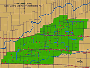
The 16 mile long main canal has an initial capaCity of 165 cubic feet per second. The canal follows and easterly and north easterly direction to the project lands east of San Angelo. A 39 mile system of concrete lined laterals completes the distribution of irrigation water. The District also includes about 15 miles of dirt wasteways.
The irrigation canal was completed in 1962; however, the first irrigation water was not released until 10 years later in 1972 when there was ample storage in the Twin Buttes Reservoir where the storage water is captured and stored. The Tom Green County WCID #1 is served by a concrete lined canal with 117 field turn-outs providing irrigation water for approximately 10,000 to 15,000 acres of farmland. The canal extends from Lake Nasworthy where the headgate is located to Veribest, Texas some 20 miles east and finally drains into the Concho River about 5 miles northeast of Veribest. The District office is also located in Veribest. Veribest is located about 10 miles east of San Angelo, Texas on Hwy 380. The District facilities include a main office building, a shop and three storage sheds.
The total acreage in the District is 30,000 acres. Only 10,000 to 15,000 acres are presently being irrigated. There are no plans now for any additional construction. Congress has passed legislation that amended our contract with Reclamation allowing for watering additional acres. This provided the farmers flexibility in irrigating their land. The original contract designated specific tracts of land that could be watered with project water. This caused an extreme hardship on the farmers as they were not able to comply with the Federal farm programs by crop rotation and other requirements. Since Congress amended the Contract, the farmers now have more flexibility in their farming operations and can irrigate a few more acres of land even though they do not get any more water. They can rotate a crop from one side of the field to the other each year and get to irrigate without being in violation of watering outside of the designated tract. This was the only change from the original irrigated acreage.
|